TOLEDO, OH — Waves of rain and thunderstorms have been parked over parts of the region for hours as of 5:50 AM, with the soggy setup expected to continue through the morning commute. A few spots have already picked up 1 to 2 inches of rain since last night, leading to pockets of localized flooding, and while nothing severe is out there, some storms can still kick out 25 to 40 mph gusts as they move through.
Storms Parked Over the Region for Hours
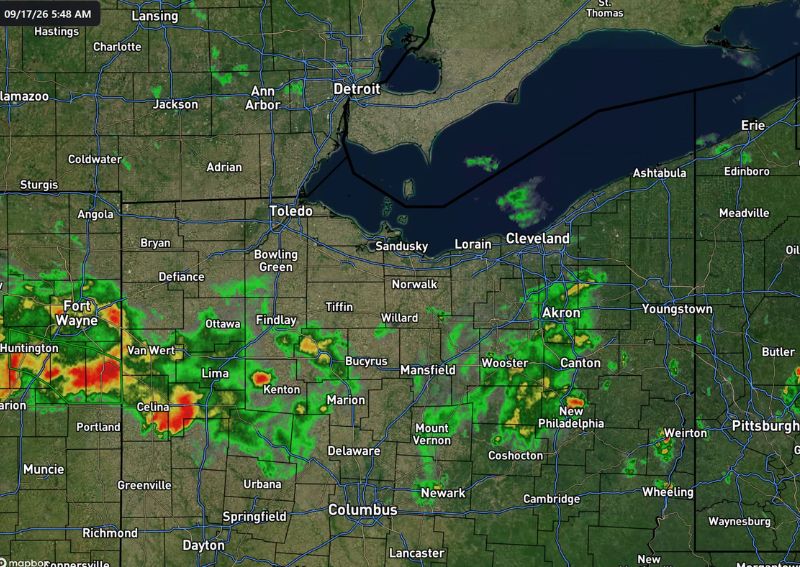
Radar imagery from 5:48 AM shows extensive rain and thunderstorm activity stretching across a wide swath of northwestern and central Ohio, with the most intense cells, shown in red and orange coloring, concentrated near Fort Wayne, Van Wert, Celina, and Lima. This activity has remained parked over parts of the region for hours, a pattern consistent with slow-moving or repeatedly redeveloping storms rather than a fast-moving system passing quickly through.
Additional pockets of heavier activity are visible farther east near Mansfield, Wooster, and New Philadelphia, indicating the overall footprint of this morning’s rain and storms extends well beyond just the most intense western corridor.
1 to 2 Inches of Rain Already Recorded
Forecasters confirmed that a few spots have already picked up 1 to 2 inches of rain since last night, an accumulation substantial enough to lead to pockets of localized flooding across the affected communities. This kind of overnight total reflects the sustained nature of tonight’s rain, building up gradually as waves of storms continued moving through the same general areas over an extended period.
Communities within the most active radar corridor, particularly near Van Wert, Celina, and Lima, are likely among those seeing the higher end of this rainfall range, given the persistent, intense activity visible in that specific area on this morning’s radar.
Soggy Setup Continues Through the Morning Commute
Forecasters were clear that this soggy setup is expected to continue through the morning commute, meaning residents heading to work or school across the affected region should prepare for continued wet roads and reduced visibility during the drive. This extended timeline suggests the rain and storm activity will not clear out quickly, but rather persist for at least the next several hours into the start of the day.
Given the ongoing nature of this activity, commuters across communities from Fort Wayne through Toledo and toward Mansfield should factor in extra travel time and exercise caution given the wet road conditions likely to persist through the morning hours.
Localized Flooding Pockets Developing
With 1 to 2 inches of rain already recorded in some spots, forecasters specifically noted pockets of localized flooding developing across the region. This kind of flooding typically concentrates in low-lying areas, poor drainage locations, and spots where repeated rounds of rain have compounded on top of already-saturated ground from earlier overnight activity.
Residents in areas known to experience drainage issues during heavy rain should remain particularly cautious this morning, given the combination of substantial overnight totals and continued rain expected through the commute period.
Nothing Severe, But Gusts Up to 40 MPH Possible
Forecasters were reassuring in noting that nothing severe is expected out there this morning, distinguishing today’s activity from a more serious severe weather event. However, they cautioned that some of these storms can still kick out 25 to 40 mph gusts as they move through, a detail worth noting even in the absence of a formal severe weather threat.
These kinds of gusty conditions, while falling short of severe criteria, can still be enough to cause minor disruptions, such as blowing around loose debris or making high-profile vehicle travel slightly more challenging during the passage of the stronger cells.
A Wide Corridor Affected Across Ohio and Indiana
The overall footprint of this morning’s rain and storms spans from Fort Wayne, Indiana through Toledo, Lima, and Mansfield in Ohio, with additional activity extending toward Akron, Canton, and New Philadelphia farther east. This broad geographic reach means a substantial portion of northwestern and central Ohio, along with parts of eastern Indiana, are experiencing some form of rain or thunderstorm impact this morning.
What Residents Should Expect
Residents across northwestern and central Ohio, particularly near Fort Wayne, Toledo, Lima, and Mansfield, should prepare for continued rain and thunderstorms through the morning commute, with the possibility of localized flooding in areas that have already seen 1 to 2 inches of rain overnight. While nothing severe is expected, residents should still be mindful of gusty winds up to 40 mph as some of the stronger cells move through the region.