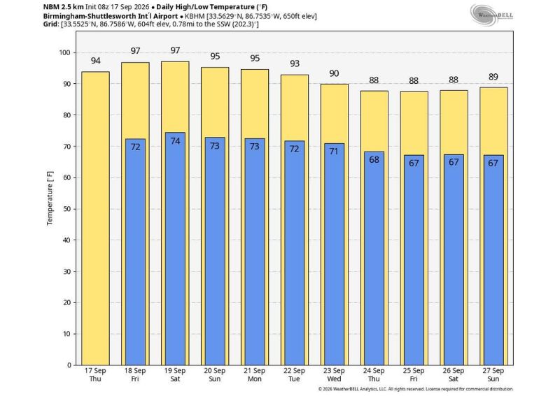
BIRMINGHAM, AL — Elevated heat levels will remain locked over Alabama through the weekend as a stubborn upper high hangs tough over the region, with temperatures rising well into the 90s and a few spots potentially touching the 100 degree mark tomorrow and Saturday. Forecasters say this represents 10 to 15 degrees above average, close to record levels for this point in September.
Ridge Keeps Its Grip Through the Weekend
Forecast data shows Birmingham reaching 97 degrees both Friday and Saturday, with the ridge responsible for this extended heat showing no significant signs of weakening through the immediate weekend period. Sunday follows closely behind at 95 degrees, continuing the run of well-above-normal readings that has defined this stretch of September weather.
This persistence reflects a well-established upper-level high pressure system that has settled firmly over the region, effectively blocking any meaningful cooling influence from reaching Alabama and keeping the state locked into this unusually hot pattern for the time of year.
A Few Spots Could Touch 100 Degrees
Forecasters specifically flagged the potential for a few locations to touch the 100 degree mark on both tomorrow and Saturday, representing the peak intensity of this ongoing heat wave. Reaching triple digits in mid-to-late September is a notable departure from typical seasonal norms, underscoring just how anomalous this stretch of weather has become for the region.
This kind of extreme heat, arriving well outside the traditional peak summer months, places additional strain on residents who might otherwise expect at least some cooling trend to be underway by this point in the calendar.
10 to 15 Degrees Above Average, Near Record Levels
Forecasters emphasized that current temperatures are running 10 to 15 degrees above average, a substantial departure that puts this stretch close to record territory for the date. This kind of significant deviation from normal conditions highlights how unusual and persistent this particular heat event has become, rather than representing a brief, isolated warm spell.
For a region typically transitioning toward cooler, more comfortable conditions by mid-to-late September, this level of departure from seasonal norms represents a genuinely notable weather story extending well beyond routine late-summer warmth.
Little Rain Relief Expected
Along with the heat comes a lack of rain, with forecasters noting that a few afternoon or evening showers are possible but will remain few and far between. This combination of extreme heat and limited precipitation compounds the discomfort for residents, since the dry conditions offer no meaningful relief from the oppressive warmth dominating the forecast.
The scattered, unreliable nature of these isolated shower chances means most areas across Alabama should not count on rainfall to provide any consistent break from the heat through the coming days.
Next Week Brings Only Gradual Improvement
Looking ahead, forecasters indicated the large-scale pattern won’t change much initially, with highs holding in the 90s for the first half of next week. Forecast data shows Monday at 95 degrees and Tuesday at 93 degrees, continuing the elevated pattern before any meaningful shift begins to take hold.
The ridge is expected to weaken a bit Wednesday through Friday, when highs are forecast to drop into the 86 to 92 degree range, based on data showing Wednesday at 90 degrees and Thursday, Friday, and Saturday all in the 88 degree range. Afternoon showers are expected to remain isolated even during this slightly cooler stretch.
No Sign of the First Good Fall Front Yet
Perhaps the most significant detail for residents hoping for genuine relief is forecasters’ assessment that there is still no sign of the first good front of the fall season, the kind of system that would bring overnight lows down into the 40s and 50s. According to the outlook, residents will have to wait until October for that first true taste of fall weather.
This extended timeline means the current stretch of heat, even as it gradually eases slightly next week, will not give way to genuinely fall-like conditions anytime in the immediate future, leaving Alabama residents facing an unusually prolonged transition away from summer heat this year.
What Residents Should Expect
Residents across Alabama should prepare for continued dangerous heat through the weekend, with highs in the 90s and the possibility of 100-degree readings in some spots on both Friday and Saturday. With the ridge only gradually weakening into next week and the first real fall front not expected until October, residents should continue taking heat safety precautions seriously for the foreseeable future.