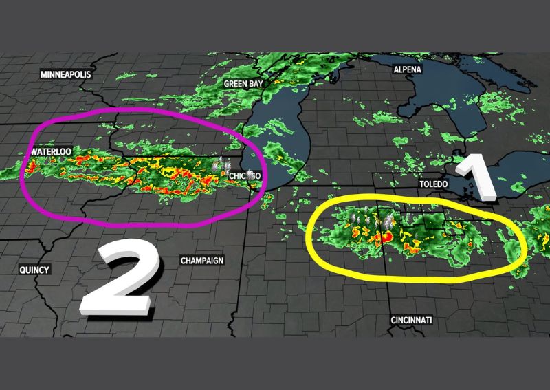
TOLEDO, OH — Two distinct rounds of rain are moving through the region today, with forecasters warning that both waves could lead to flash flooding across Indiana and parts of Ohio. Beyond today’s activity, forecasters say there’s more where this came from, with heavy weekend rain also possible as the pattern continues.
Round One Targets Toledo and Northwest Ohio
Radar and satellite imagery from 6:14 AM shows the first highlighted wave, marked as Round 1, tracking through a corridor stretching from near Toledo westward across northwestern Ohio. This system shows areas of moderate to heavy rainfall, indicated by the green and yellow coloring on the radar, with the storm’s positioning placing it directly in the path of communities across that portion of the state.
This first round represents the more immediate threat for residents in and around Toledo, given its current position and the ongoing nature of the rainfall visible within the highlighted zone as of this morning’s radar update.
Round Two Tracks Through Waterloo and Chicago
The second wave, labeled Round 2, is positioned farther west, stretching from near Waterloo through the Chicago area, and displays some of the more intense radar returns on today’s map, including notable red coloring indicating heavier rainfall rates within that system. This second round trails behind the first, suggesting communities in its path should expect their own period of potentially heavy rain as this system continues moving eastward later in the day.
The presence of two separate, well-defined rounds rather than a single continuous rain event means today’s weather will likely feel like distinct waves passing through, with the possibility of drier interludes between the two systems for areas positioned between them.
Flash Flooding Concerns for Both Waves
Forecasters specifically flagged the potential for flash flooding with both of today’s rain rounds, a concern tied to the kind of heavy rainfall rates visible within the most intense portions of each highlighted system. This dual flash flooding concern means residents across both Indiana and parts of Ohio should stay alert as each wave moves through their specific area throughout the day.
Given that two separate systems carry this flooding potential, any location that ends up in the path of both rounds could see cumulative rainfall totals significant enough to compound flooding risks, particularly in low-lying or poor-drainage areas.
More Rain on the Way This Weekend
Beyond today’s two rounds, forecasters indicated there’s more where this came from, with heavy rain also possible over the weekend. This suggests today’s activity represents just the beginning of an extended stretch of unsettled, potentially flood-prone weather rather than a single, isolated rain event confined to just today.
This extended outlook means residents across the affected region should prepare for the possibility of repeated rounds of heavy rain continuing beyond today, adding to any cumulative flooding concerns that develop from the two waves currently tracking through the area this morning.
A Multi-Round Pattern Takes Shape
The clear identification of today’s rain as two separate, trackable rounds, combined with the mention of additional heavy rain possible this weekend, points to a broader multi-day pattern of unsettled weather affecting the Great Lakes and Ohio Valley region. This kind of extended, wave-after-wave setup often produces cumulative rainfall totals that exceed what any single round would suggest on its own.
Communities positioned along the path of both today’s rounds and any weekend systems that follow should be particularly mindful of how quickly saturated ground and already-elevated waterways could respond to additional rainfall arriving before conditions have a chance to fully recover.
What Residents Should Expect
Residents across Indiana and parts of Ohio, particularly near Toledo, Chicago, and Waterloo, should prepare for two distinct rounds of rain today, both carrying the potential for flash flooding in vulnerable areas. With additional heavy rain possible over the weekend, residents should stay tuned to updated forecasts as this multi-day unsettled pattern continues to unfold across the region.