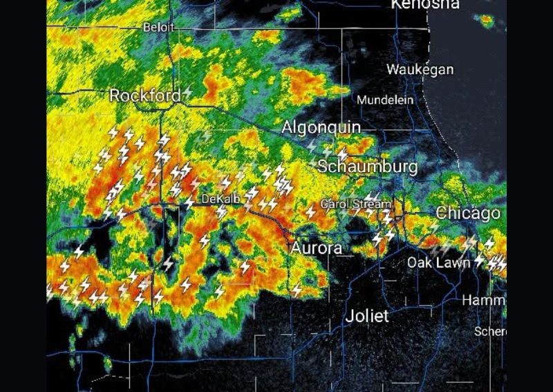
ROCKFORD, IL — A broad line of heavy thunderstorms pushed through northern Illinois before dawn on Thursday, cutting across the region from Rockford and Beloit in the west through DeKalb, Algonquin, Schaumburg, and Aurora, extending toward the outer Chicago suburbs and Oak Lawn. Radar imagery captured the storm line stretching across a wide swath of the region, with lightning activity concentrated heavily along the Rockford to Aurora corridor. The system tracked farther north than initial forecasts had indicated, arriving with sustained intensity through the early morning hours.
No Severe Weather Warnings in Effect
Despite the widespread coverage and persistent lightning, the storm line was not associated with any severe thunderstorm warnings or tornado warnings at the time of observation. The activity was categorized as a standard round of heavy thunderstorms rather than a severe weather outbreak. Forecasters noted that while the storms carried significant rainfall and frequent lightning, wind gusts and hail were not expected to reach warning-criteria thresholds across the affected counties, including Boone, DeKalb, Kane, and DuPage.
Street Flooding Concerns in Low-Lying Areas
The primary hazard tied to this system was localized street flooding, particularly in poor drainage areas throughout the Rockford and Aurora corridor. Heavy rainfall rates embedded within the storm line raised the potential for rapid water accumulation on roadways, especially in low-lying neighborhoods and underpasses. Residents commuting during the early morning hours were urged to use caution, as ponding water can develop quickly even without a formal flood warning in place. The DeKalb and Carol Stream areas showed some of the most persistent lightning and rainfall signatures on radar.
Storm Duration and Regional Impact
The disturbance was expected to persist for several hours as it continued tracking eastward across northern Illinois toward the Chicago metro area. The line’s northward shift from earlier projections meant communities near Kenosha and Waukegan along the Wisconsin border also fell within reach of the heaviest activity. Meteorologists tracking the system noted its unusual overnight timing, with the bulk of the heavy thunderstorms arriving well before sunrise and disrupting sleep for residents across the corridor stretching from Rockford to Joliet.
Outlook for Thursday Morning Commute
As the storm line continues its eastward progression, residents across northern Illinois should anticipate lingering rain showers and reduced visibility into the Thursday morning commute. While no severe weather is expected to develop, the combination of saturated ground and continued rainfall keeps localized street flooding a concern in drainage-prone areas through the morning hours. Motorists are advised to avoid flooded roadways and allow extra travel time as the system clears the region.